
Reading Time: 3 minutes
TL;DR: Google Maps doesn’t offer built-in drive-time or radius search features, but third-party tools like TravelTime and FreeMapTools provide these capabilities. These tools help businesses identify service areas within specific time or distance limits from their locations. Route optimization tools like Zeo Route Planner address this with AI-powered route optimization and bulk address import features, helping delivery teams save 2+ hours daily.
You’ve got a delivery hub in the middle of the city. You need to figure out which customers you can serve within 30 minutes. Or maybe you’re opening a new store and want to reach people within 10 miles. You open Google Maps, expecting to find a feature that lets you draw a circle or set a drive-time limit. But after clicking around, you realize there’s no simple button for that.
You’re not alone. Many business owners, drivers, and service managers face this same problem. That’s where the idea of a Google map drive time radius comes in. And while Google Maps doesn’t offer this directly, there are smart workarounds and tools that make it possible.
What Is a Drive-time or Radius Search?
When you want to know how far you can reach from a specific location, either by time or by distance, you use a Search by Drive-time or a Search by Radius.
A Search by Drive-time helps you see which places you can reach within a certain number of minutes by road. For example, if you want to find all delivery stops that are within 20 minutes from your warehouse, this method gives you that area clearly on the map.
On the other hand, a Search by Radius draws a circle around your chosen point based on distance. So if you want to check which locations fall within 10 or 15 kilometers from your base, this is the tool to use.
These tools are especially useful for delivery and service businesses. By knowing which areas are within reach, you can plan smarter routes, reduce fuel costs, and save time. If you’re using a Google map drive time radius tool, you get a clear picture of your delivery or service area without any guesswork.
What Google Maps Can and Cannot Do
Google Maps is great for many things. You can get directions, check business hours, or explore nearby restaurants. But when it comes to Search by Drive-time or drawing a Search by Radius, it doesn’t have a built-in tool.
You can’t say “show me everything within 20 minutes from this spot” or “highlight a 10-mile circle around this location” in Google Maps itself. This is where many users get stuck.
What you can do in Google Maps is check travel times between two points. But if you want to view a wider area or multiple stops within a certain range, you need a different approach.
Why Geographic Analysis Matters for Business Operations
Understanding your service radius isn’t just about convenience—it directly impacts your bottom line. According to the U.S. Department of Transportation, businesses that properly analyze their geographic service areas can reduce operational costs by up to 25% through optimized routing and resource allocation.
Service area mapping helps businesses make data-driven decisions about expansion, pricing, and resource deployment. Companies use this information to determine delivery fees, establish service boundaries, and identify underserved markets. The ability to visualize drive-time accessibility also helps businesses comply with service level agreements and manage customer expectations more effectively.
Tools That Help You Search by Drive-time or Radius
There are third-party tools that help you perform a Google map drive time radius search. Some of the most popular ones include:
- TravelTime: Lets you enter a time limit and shows areas reachable within that range.
- FreeMapTools: Offers a simple interface to draw distance-based circles on a map.
- Map Developers: Allows you to create and export radius maps with ease.
These tools use Google Maps in the background but add the missing layer of functionality. You can search by drive-time or draw custom radius zones and then plan your work accordingly.
Industry Applications of Drive-Time Analysis
Different industries leverage drive-time and radius mapping for various purposes. Food delivery services use these tools to establish delivery zones and calculate accurate delivery times. Emergency services rely on drive-time analysis to ensure response times meet regulatory requirements. Retail businesses use radius mapping to analyze market penetration and competitor proximity.
increase fuel savings
Hassle Free Deliveries & Pickups!
Optimize routes with our algorithm, reducing travel time and costs efficiently.
Get Started for Free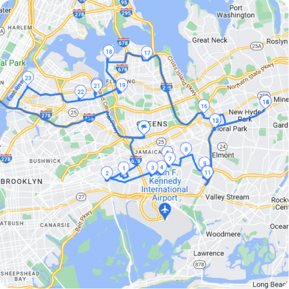
Construction and field service companies particularly benefit from this analysis. Projects like construction site services require precise geographic planning to manage multiple locations efficiently. Similarly, telecom field service operations use drive-time mapping to assign technicians to service areas and reduce travel time between appointments.
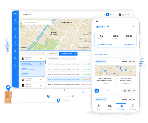
How Zeo Helps You Use Radius and Drive-Time Data Better
Third-party tools can help you Search by Drive-time or Search by Radius on a map. These tools let you visualize which areas fall within a specific distance or driving time from your starting point. It’s great for identifying reachable customers or delivery zones. But once you have that information, what’s next?
That’s where Zeo Route Planner steps in.
Zeo doesn’t just show you a circle on the map. It helps you act on it. After you’ve used a tool to find your target area, Zeo lets you import those stops and plan the most efficient delivery routes in seconds.
Here’s how Zeo adds value:
- Smart Route Optimization: Zeo takes your list of stops, whether chosen by drive-time or radius, and builds the fastest, most efficient route. You save hours on planning and cut fuel costs.
- Bulk Uploads: Simply export stops from your device, upload them into Zeo, and you’re ready to roll.
- Priority Sorting: Zeo lets you sort by delivery windows, location priority, or driver availability, so you’re not just reaching stops, but reaching them smartly.
- Time & Cost Savings: Planning routes manually from radius data can be tedious. Zeo handles it all, giving you more time to focus on deliveries and customer satisfaction.
So while Google map drive time radius tools help you define your reach, Zeo helps you optimize your routes within that reach. Together, they give you the full picture, from planning to performance.
Final Thoughts
Being able to Search by Drive-time or Search by Radius helps you make better decisions. It tells you where your business can reach, how fast, and with how much effort. Even though you can’t perform a Google map drive time radius search directly in Google Maps, you can easily do it with the right tools.
If you want something that’s not only visual but also actionable, Zeo Route Planner is a great choice. It combines location insights with practical route planning so you can turn circles and time zones into real results.
Frequently Asked Questions
How accurate are drive-time calculations for business planning?
Drive-time calculations are generally accurate within 5-10% for normal traffic conditions, but accuracy varies based on real-time traffic, weather, and road conditions. Most mapping APIs update traffic data every few minutes to provide realistic estimates. For business planning, it’s recommended to add a 10-15% buffer to account for unexpected delays.
Can I create custom service zones that aren’t perfect circles?
Yes, many advanced mapping tools allow you to create irregular polygons and custom service boundaries that follow roads, city limits, or geographic features rather than simple radius circles. These custom zones provide more realistic service areas that account for actual accessibility and business constraints.
What’s the difference between straight-line distance and actual driving distance?
Straight-line distance (as the crow flies) measures the direct distance between two points, while driving distance follows actual roads and can be 20-40% longer in urban areas. Drive-time analysis considers road networks, traffic patterns, and speed limits to provide realistic travel estimates for route planning.
How do I import radius search results into route planning software?
Most radius mapping tools allow you to export results as CSV or Excel files containing addresses and coordinates. Route optimization platforms like Zeo Route Planner support bulk address import from spreadsheets, automatically converting your geographic analysis into optimized delivery routes with time window constraints.
What factors should I consider when setting delivery radius limits?
Consider vehicle capacity, driver work hours, fuel costs, delivery time windows, and competition when setting radius limits. Urban areas typically support smaller radiuses with higher stop density, while rural areas may require larger service zones. Factor in return travel time to your depot and local traffic patterns during peak delivery hours.
Are you a fleet owner?
Want to manage your drivers and deliveries easily?
Grow your business effortlessly with Zeo Routes Planner – optimize routes and manage multiple drivers with ease.
increase fuel savings
Hassle Free Deliveries & Pickups!
Optimize routes with our algorithm, reducing travel time and costs efficiently.
Get Started for Free