
Updated on: October 6, 2025
APIs fuel modern routing. But if you’ve scaled past a few dozen requests a day, you’ve probably felt the squeeze of Google Maps pricing. Every added call chips into margins, and suddenly your routing budget grows faster than your fleet.
Google Maps works well, until pricing pressure hits growth. It’s obvious that teams will need control, clear limits, and stable performance.
OpenStreetMap (OSM) offers a way out. It’s free, community-built, and detailed enough to rival commercial datasets. More importantly, it gives you control: no locked pricing tiers, no hidden limits. Pair OSM with routing engines like OSRM, Valhalla, or GraphHopper, and you can run navigation at scale without breaking budgets.
More on this follows!
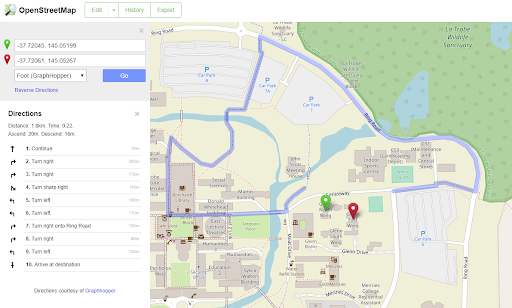
What is OpenStreetMap?
Users often cite OpenStreetMap (OSM) as “Wikipedia of maps.” It is a freely available, community-maintained map of the world where millions of volunteers, companies, and researchers contribute to.
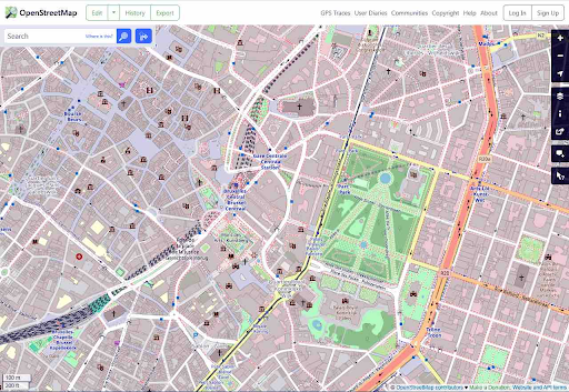
The best thing is that the dataset is constantly updated from small-town streets to new bike paths to detailed postal codes. That’s why it is one of the most versatile mapping sources available today.
With OSM, you get:
- Comprehensive data of roads, footpaths, waterways, addresses, landmarks, and even building footprints
- Global coverage across cities and even remote areas with consistent data access
- Regular updates where volunteers and partners contribute edits daily and make sure of local accuracy that often surpasses proprietary datasets
- Free licensing which is not the case with Google Maps because there’s no need to pay per API request. It’s possible to host your own copy or use existing APIs built on OSM data
Non-profits like the Red Cross use OSM to map disaster zones, where commercial maps often lag. On the business end, logistics startups use OSM-backed engines to cut costs while still delivering precise routing and ETAs.
How OpenStreetMap Routing Guide Functions
OSM gives you the raw map data of roads, intersections, and attributes built on the routing engines that turn those tiles into usable directions. It does so by parsing graph structures, calculating weights, and running shortest-path algorithms.
The three most widely adopted are OSRM, Valhalla, and GraphHopper. Each brings different strengths depending on whether you need raw speed, flexible transport modes, or customization at the fleet level.
OSRM (Open Source Routing Machine)
OSRM is essentially a lightning-fast shortest path solver built in C++. It preprocesses OSM data into a highly optimized routing graph and then answers queries in milliseconds.
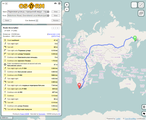
- Scaling with speed becomes possible: OSRM can handle thousands of requests per second when it is deployed on a strong hardware. This is why businesses use it for high-traffic apps like ride-hailing or delivery marketplaces.
- Provide variable profiles: This includes ships with car, bicycle, and even walking spaces. Also, the advanced users can define custom weightings like preferring highways or avoiding toll roads.
- Opens way for private hosting: Many companies run OSRM in-house to avoid usage costs and keep data local. This is super important in industries with strict compliance needs.
The only trade-off is that of heavy preprocessing. Updating the graph with fresh OSM data takes time, which means OSRM shines where performance matters more than hyper-frequent map refreshes.
Valhalla
Valhalla is a C++ open-source routing engine that’s built on OpenStreetMap data. It supports cars, bikes, and walking by default, plus, there are features like matrix queries, isochrones, map matching, and turn-by-turn guidance.
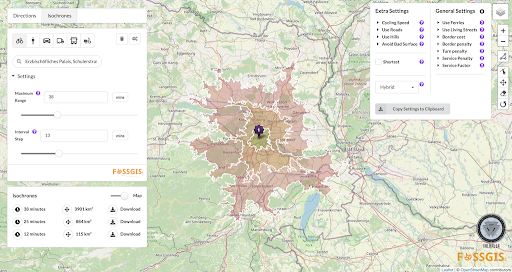
The added GTFS transit feeds to it so that it enables multimodal routing across buses, trains, and walking.

increase fuel savings
Save $200 on fuel, Monthly!
Optimize routes with our algorithm, reducing travel time and costs efficiently.
Get Started for Free
GraphHopper
GraphHopper is Java-based and known for being lightweight yet highly configurable. This makes it appealing for SMBs and mid-market logistics operators who demand control without a huge infrastructure lift.
With GraphHopper, it gets possible to:
- Drive customization by adding constraints such as vehicle height, weight, hazmat restrictions, or delivery time windows
- Boost efficiency since it runs comfortably on modest servers so that the smaller fleets can self-host without major cloud costs
- Avail commercial support with hosted API tier for businesses that prefer not to manage their own servers
Often, it’s the distributors or couriers organization that use GraphHopper as they need nuanced routing logic (e.g., trucks restricted by city ordinances) but don’t want the operational complexity of OSRM.
Why OpenStreetMap Routing Is a Free Alternative to Google Maps API
Google Maps API is powerful but there are licensing fees that scale quickly once usage grows. Every route request, distance matrix call, or ETA calculation adds to the bill.
Now, take OpenStreetMap (OSM) and it combines with engines like OSRM, Valhalla, or GraphHopper that have the same core capabilities. There’s also the turn-by-turn routing, ETA calculations, matrix queries, and map matching without any per-request charges.
Use OSM to host these engines yourself and get unlimited queries at the cost of running your own server. For smaller teams, cloud-hosted services built on OSM (e.g., Mapbox, Stadia Maps) give a middle ground: open-data power with managed infrastructure.
Costings
Google Maps API: Let say, you’re using the dynamic map loads. They are billed around $7 per 1,000 requests, while distance matrix and route SKUs can run anywhere from $5 to $30 per 1,000 calls depending on type and region. At scale, that can mean thousands of dollars a month just for routing and ETA calculations.
OSM: This one changes the math since the map data is free, open, and global. The spend shifts from usage fees to infrastructure choices. With self-host using OSRM or Valhalla, you are essentially paying for cloud servers (entry-level instances start near $50/month, heavier builds for country-wide data can cost a few thousand annually).
Businesses having technical teams may find this tradeoff appealing because instead of per-transaction costs, there’s only predictable infrastructure to pay for.
| Feature/Cost Area | Google Maps API | OSM Self-Hosting (OSRM/Valhalla/GraphHopper) | OSM Hosted Services (Mapbox/Stadia, etc.) |
| Data Licensing | Proprietary, paid per API call | Free, open (OpenStreetMap) | Free OSM data, but hosted provider adds usage fees |
| Pricing Model | $5–30 per 1,000 calls depending on API | Server/cloud cost (from ~$50/month for small regions to a few $k/year for full country/global data) | Lower per-call rates than Google (often 30–50% cheaper), transparent tiers |
| Scalability | Scales instantly, but costs rise sharply with volume | Scales with your server capacity; predictable spend | Scales with provider; costs grow slower than Google |
| Feature Set | Polished APIs, traffic, ETAs, geocoding, Street View | Depends on engine: OSRM (speed), Valhalla (multi-modal, isochrones), GraphHopper (lightweight, custom rules) | Provider bundles advanced features (tiles, directions, analytics) |
| Control & Customization | Limited; black-box algorithms | Full control; tune routing profiles, vehicle limits, service windows | Moderate; provider adds customization layers but not as open as self-hosted |
| Best Fit | Teams who want out-of-the-box ease and can absorb costs | Businesses with in-house tech or dev partners; high call volumes | SMEs needing lower rates + some flexibility without full self-hosting |
Conclusion
Choosing between Google Maps and OpenStreetMap routing comes down to control and cost. Google delivers polished APIs but at steep, scaling fees.
OSM, whether self-hosted or via a managed provider, provides freedom, transparency, and long-term savings.
For teams ready to balance performance with predictability, OSM is a practical step toward owning your routing future.
Are you a fleet owner?
Want to manage your drivers and deliveries easily?
Grow your business effortlessly with Zeo Routes Planner – optimize routes and manage multiple drivers with ease.
increase fuel savings
Save $200 on fuel, Monthly!
Optimize routes with our algorithm, reducing travel time and costs efficiently.
Get Started for Free